


Breaking news


Canadian Coast Guard conduct sea trials of the Shield AI V-BAT UAS.
According to information published on January 26, 2022, Kongsberg Geospatial announced today they successfully conducted sea trials of the Shield AI V-BAT Unmanned Aerial System (UAS) on behalf of the Canadian Coast Guard, operating from a small cargo vessel far offshore in international waters.
Follow Navy Recognition on Google News at this link
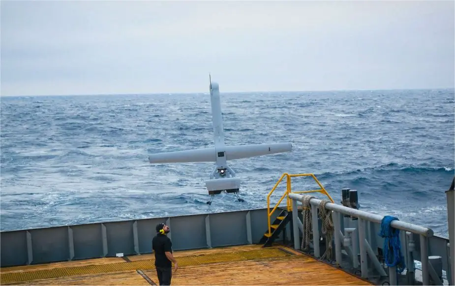 Shield AI V-BAT Unmanned Aircraft Systems (Picture source: Kongsberg)
The Canadian Coast Guard is conducting trials of the long-endurance Vertical Take-of and Landing (VTOL) UAS surveillance system for possible deployment on Canadian Coast Guard Vessels under a project funded by Defence Research and Development Canada (DRDC).
The Shield AI V-BAT aircraft was selected due to its unique ability to combine VTOL from the small confines aboard ship with the long endurance of a fixed-wing aircraft while carrying multiple sensors.
Kongsberg Geospatial teamed with Shield AI to deploy the V-BAT VTOL UAS for a 3-day sea trial in international waters in the Gulf of Mexico. The trials tested the capability of the aircraft to provide rapid launch and recovery, long-endurance, and confined space take-off and landing from a moving vessel in a variety of weather conditions – both during the day and at night.
In addition to tracking and identifying other ships at long ranges, the flights conducted a variety of simulated missions designed to emulate real-world situations where the Canadian Coast Guard would use the drones. These included locating and tracking dye patches that simulated wreckage or oil spills and locating life preservers in choppy seas and in a variety of weather conditions.
The V-BAT operators used Kongsberg Geospatial’s IRIS UxS software to safely pilot the aircraft at long ranges from the launch vessel.
The IRIS software provides a comprehensive situational awareness picture of the operational airspace, data from a variety of sensors and data feeds – and shows the location of other aircraft and surface ships, as well as the launch vessel and the “ownship”, or drone being operated.
Sensor data feeds from the cameras and sensors carried by the UAS were ingested, in real-time, into the Kongsberg Geospatial Modular ISR Data Analysis and Storage System (MIDAS).
The MIDAS system records video and other data from the UAS, and serves as a “mission intelligence coordinator” to view current and historical sensor feeds of the UAS within a temporal and geospatial context to increase sensor utilization effectiveness.
The V-Bat aerial system design features fixed wings and a slender fuselage. It is powered by a 157 cc, two-stroke engine, which generates an output power of 13 hp. The drone can fly at a maximum speed of 90 knots and offers a range of 300 nautical miles.
It can operate at an altitude of 15,000 feet and in wind speeds up to 25 knots. It can perform continuous operations for up to eight hours at a speed of 40 knots.